Tropical Storm Noel Teases FL
Forecasters keep eye on storm as it passes through the Islands of the Bahamas
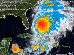
Posted Thursday, November 1, 2007
...Noel accelerating through the Bahamas... A Hurricane Watch remains in effect for the northwestern Bahamas. A Tropical Storm Warning remains in effect for the central and northwestern Bahamas.
A Gale Warning remains in effect for Bermuda.
For storm information specific to your area...including possible inland watches and warnings...please monitor products issued by your local weather office.
At 500 PM EDT...2100z...the center of Tropical Storm Noel was located near latitude 25.5 north...longitude 77.1 west or about 40 miles... 65 km...north-northeast of Nassau and about 205 miles...330 km...east-southeast of West Palm Beach Florida.
Noel is moving toward the north-northeast near 14 mph...22 km/hr. An increase in forward speed is expected over the next 24 hours.
Maximum sustained winds are near 65 mph...100 km/hr...with higher gusts. Noel is expected to lose tropical characteristics over the next 24 hours or so...but then strengthen and increase in size as an extratropical cyclone. Interests along the U.S. East Coast from North Carolina northward should consult statements issued by their local NWS forecast office.
Tropical storm force winds extend outward up to 115 miles...185 km from the center.
Estimated minimum central pressure is 993 mb...29.32 inches.
Above normal tides are likely within the warning areas.
Noel is expected to produce total rainfall accumulations of 5 to 10 inches in the Bahamas...with possible maximum amounts of 18 inches. Additional rainfall accumulations of 1 to 2 inches are expected over eastern Cuba...where these rains could cause life-threatening flash floods and mud slides. Rainfall amounts of an inch or so are possible across the Outer Banks of North Carolina.
Repeating the 500 PM EDT position...25.5 N...77.1 W. Movement toward...north-northeast near 14 mph. Maximum sustained winds...65 mph. Minimum central pressure...993 mb.
An intermediate advisory will be issued by the National Hurricane Center at 800 PM EDT followed by the next complete advisory at 1100 PM EDT.
Forecaster FranklinFL House Committee Bill HWSS 15-06 Has New Number: HB 7123
Important info if you will be watching fireworks from the water in Miami
A simple, but effective tool for when emergencies happen.
FWC Online Survey Closes Today. Dec. 7
Nationwide crackdown focuses on critical safety issue affecting our local waters
Contact ~ About ~ Advertise ~ Privacy Policy ~ FAQ
Toll free 1-877-228-1569 ~ In South Florida 786-525-3545
Copyright© 1999 - 2015 Atlantic Coast Boating

![]()
SailMiami.com